

Mountain Bike Trails
The mountain bike trails in Washburn County weave through incredible hardwood forests, around crystal clear lakes, and offer some of the most amazing Northwoods views. One of the most popular trails is the Wildcat Mountain Bike Trail, located on a large parcel of county forest land. Another option for more advanced riders is the College Street/City Park Trail in Spooner where you'll find a bit more technical trails. So, pack up your bike and head out to explore the beauty that Washburn County offers.
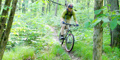
Wildcat Mountain Bike Trail
Type: Mountain Bike (A portion of the trail is fat bike friendly during the winter months)
Location: 4 miles east of Spooner, on Hwy 70
Length: 21 miles
Trail Description: A combination of single track, double tracks, portions of snowmobile/ATV trails and gravel roads provide for a wide variety of riding skills and experiences. The trail utilizes thousands of acres of Washburn County forest land, thanks to Washburn County Forestry Department’s support of biking in the area. This majestic land features mature oak, basswood, & maple stands. The many acres are also dotted with glacial lakes that offer pristine viewing. You will not find any permanent building structures here as all of this land is protected-it is basically the same land, “virgin soil”, one would have found two hundred years ago. When exploring Wildcat, you will find trails that are mowed, brushed, and marked and maintained by volunteers & local trail users, that will lead you through the many miles of wilderness. Trail users will also encounter winding climbs and descents, long gravel sections and tight single track.
Spooner City Park (College Street Park) Trail
Type: Mountain Bike
Location: Spooner
Length: 6 miles
Trail Description: There are multiple loops & dogs are welcome with a leash. The trail system offers miles of twisting single track, that feature bridges, steep climbs and descents that take riders through poplar stands to hardwoods, and even sweet smelling pine sections. There is even a section coined the “Fastest 2 Minutes” that will leave riders on the rivet as they navigate screaming, winding down hills for close to two minutes. Another nice feature of the SCP trails is that at just about anytime during your ride, you can just drop out on the ski or paved bike trails to reload, so to speak, and then jump back in for some more technical riding.
Totogatic Trail
Type: Mountain Bike
Location: North of Minong, on Hwy 53 (Address: N13611 Hwy 53, Minong, WI 54859)
Length: 5 miles
Trail Description: The Totogatic trails are a wonderful, quiet, stacked-loop trail system. The trails meander through a variety of forest types, including: red pine plantations, mixed hardwoods with occasional tall red and white pines and areas of scenic tamarack/spruce bog.The terrain ranges from flat to fun rolling hills. There are four loops: 3.8, 7.4, 8.6, and 7 km.
Wild Rivers Trail
Type: Railroad grade; surface is dirt and gravel
Location: Rice Lake to Superior
Length: 96 miles (Barron, Washburn, Douglas Counties)
Trail Description: This multi-use trail runs from Rice Lake, north through Washburn and Douglas Counties, ultimately ending at the south end of Superior. This trail is often used as a connector to the ATV and snowmobile trail systems. The trail welcomes hikers, bicyclists (mountain bike or fat bike recommended), horseback riders, ATVers, snowmobilers, cross country skiers, and snowshoers. The surface of the trail is primarily gravel and dirt. Please always remember when you are utilizing a multi-use trail to show respect to all users. Slow down and make room for others to pass by you.
Tuscobia Trail
Type: Mountain Bike
Location: Birchwood (Rice Lake to Park Falls)
Length: 74 miles (Barron, Washburn, Sawyer, Price Counties)
Trail Description: This multi-use trail runs from Rice Lake through the southeast portion of Washburn County, southern portion of Sawyer County and ends in Price County. This trail is often used as a connector to the ATV and snowmobile trail systems. The Washburn, Sawyer, and Price county portions of the trail welcomes hikers, bicyclists (mountain bike or fat bike recommended), horseback riders, ATVers, snowmobilers, cross country skiers, and snowshoers. The surface of the trail is primarily gravel and dirt. Please always remember when you are utilizing a multi-use trail to show respect to all users. Slow down and make room for others to pass by you.
Fat Bike Trails
Washburn County offers two great two systems for winter riding. Snowshoers are encouraged to use these trails as it helps keep them packed down & in good riding conditions for the fat bikes. Parking is available at both of the trail heads with easy access to the trails to start your riding adventure! Want to know how the trails are before heading out? Check out the trail conditions here. Volunteer groomers send us honest, up-to-date information about the trails so you know what to expect before you get to the trails. Enjoy your ride!
Wildcat Trails
Type: Winter Fat Biking
Location: 4 Miles East of Spooner, on Highway 70, parking on south side of the highway
Length: 10 Miles of Groomed Trails
Trail Description: A combination of single and double track provide for a wide variety of riding skills & experiences. The trail utilizes thousands of acres of Washburn County forest land, thanks to the Washburn County Forestry Department's support of biking in the area. The trail is groomed by Wildcat Volunteer Groomers and is maintained by the Wildcat Mountain Bike Club. The trails wind through a variety of different tree types such as mature oak, basswood, and maple. In addition there are sections that take you through hundreds of poplar trees that remind you of Aspen, Colorado. The many acres are also dotted with glacial lakes that offer pristine viewing. You will not find any permanent building structures here as all of this land is protected - it is basically the same land one would have found two hundred years ago.
When exploring Wildcat, trail users will also encounter winding climbs & descents and of course, and abundance of wildlife.
View Map of Winter Groomed Trails
Spooner City Park (College St.) Trail
Type: Winter Fat Biking
Location: Spooner, follow College Street to the end and you'll find the entrance to the park
Length: 4 Miles of Trails
Trail Description: These trails located right in town offer a great spot for winter biking. The trails are not currently groomed, but frequent snowshoeing keeps the trails in pretty decent condition. The trails offer a wooded, hilly ride and easy access to a warming house. Please note the single track tails are a little too tight to fit a groomer through to keep them packed down - so depending on the time year you may encounter trails slightly softer.
Road Bike/Paved Trails
The quiet, country roads of Washburn County have drawn thousands of bicycle enthusiasts to explore Washburn County's country side over the years. In addition, the city of Shell Lake and the city of Spooner are working on expanding their paved trails to provide a safe, off-road, paved biking experience for families. Please keep checking back as new trails are added.
Spooner Paved Trail
Type: Paved
Location: Spooner; connecting the Elementary, Middle & High Schools
Trail Description: One mile of paved trail with parking available at College Street/Spooner City Park.
Washburn County Road System
Type: Paved/Unpaved
Location: Multiple options
Length: Multiple options
Trail Description: The roads of Washburn County are available to bicycle enthusiasts. Many of the county and town roads are quiet, allowing for a scenic bike ride. Please be sure to observe all road safety laws and safety recommendations.

